http://rpc.technorati.com/rpc/ping

Ganges Delta

. . . roll-over image links for previews or follow the theme trails by clicking on each image to proceed to the next . . .
The Ganges River forms a large delta as it enters the Bay of Bengal. The delta is mostly covered the Sunderbans, a swamp forest that is home to the Royal Bengal Tiger. (original)

Labels: , , , ,

Kimberly

. . . roll-over image links for previews or follow the theme trails by clicking on each image to proceed to the next . . .

Australia's Kimberly Plateau lies north of the Great Sandy Desert in Western Australia in this LandSat 7 image. The elongated body of water in the north of this image is the Joseph Bonaparte Gulf, a backwater of the Timor Sea. The Durack, Chamberlain, and Ord Rivers wind their way northward to this gulf.

Some of the oldest rocks on Earth, together with the oldest mineral discovered, are located in Western Australia, which is also home to the Shark Bay stromatolites and the oldest microfossil stromatolites.

. . .
Earth as Art . . .

Labels: , , , , , , ,

Delta Baja

. . . roll-over image links for previews or follow the theme trails by clicking on each image to proceed to the next . . .

This false color ASTER image is more aesthetic than the true colors of the delta formed as the Colorado River empties into the Gulf of California. The delta is suffering erosion because the Hoover and Glen Canyon Dams are preventing sediment from the upper reaches of the Colorado River from passing downstream of the dams. A similar problem affects the Nile River downriver of the Aswan Dams.

Labels: , , , , , , ,

Andes Chile

. . . roll-over image links for previews or follow the theme trails by clicking on each image to proceed to the next . . .

Cerro Luxsar in Pampa Luxsar lava complex and Olca and Paruma stratovolcanoes along the Chile-Bolivia border.

image : NASA/GSFC/METI/ERSDAC/JAROS,and U.S./Japan ASTER Science Team

Also : image of dormant volcanoes on the border between Chile and the Catamarca province of Argentina. These volcanoes have laid down a variably colored crust of solidified magma roughly 2 miles (3.2 km) thick.

Labels: , , , ,

World Mosaic


Landsat 7 World Mosaic, Dec 31,2000, gallery. Click each image to proceed to the next. Roll-over image links for previews.

Labels: ,

Aleutian Clouds


Aleutian clouds exhibit color variations that are probably due to differences in temperature and in the size of water droplets. Original image.

Also for cloud gazers : Karman Vortices in the lee of the Alexander Selkirk Island in the southern Pacific Ocean. Here are more Karman Vortices that have formed over part of the Kuril Island chain found between Russia"s Kamchatka Peninsula and Japan.

Earth as Art thumbnails.

Labels: ,

Jerusalem's Old City


An Aster* image of Jerusalem, or Yerushaláyim, or Yerushalaim. The old city, which has four quarters, is the lighter blue area in the right center of the image, and is surrounded by a 400-year-old wall built by the Ottoman Turks. Speaking of the Ottoman Turks, here are Earth Observatory images of Istanbul and of Gallipoli and the Dardanelles Strait.

image NASA/GSFC/METI/ERSDAC/JAROS,and U.S./Japan ASTER Science Team

*ASTER = Advanced Spaceborne Thermal Emission and Reflection Radiometer.


Virtual Tour of Jerusalem : high-resolution view from Mt. Olives : high-resolution view of Wailing Wall and Dome of the Rock :

Labels: , , ,

Lena Delta, Russia


The Lena River is one of the largest rivers in the world, and is 4,500km long. The Lena Delta Reserve is the most extensive protected wilderness area in Russia. It is an important refuge and breeding grounds for many species of Siberian wildlife. Original image here.

The Parana River Delta is northeast of Buenos Aires, Argentina and as a forested marshland is one of the world"s greatest bird-watching destinations.

Labels: ,

Shoemaker Impact, Australia


The Shoemaker impact structure, named for the late Eugene Shoemaker, was previously called Teague Ring. The meteor that created this structure is estimated to have impacted the Australian Shield between 1000 and 600 million years ago.

image NASA/GSFC/METI/ERSDAC/JAROS, and U.S./Japan ASTER Science Team

Landsat 7 image of same area for comparison. Landsat 7 image of Manicougan impact crater dated at 214 million years on the Canadian Shield. GloVis is the Global Visualization Viewer from the USGS.

Labels: , , , ,

Kalahari

. . . roll-over image links for previews or follow the theme trails by clicking on each image to proceed to the next . . .

The Kalahari of Africa: on the edge of the Kalahari Desert in Namibia, sand dunes are encroaching onto once-fertile lands in the north. Original image on Earth as Art site.

Labels: ,

Coachella & Salton, California


Land use in the Coachella valley, a major fruit growing region northwest of the Salton sea in California.

original image NASA/GSFC/METI/ERSDAC/JAROS,and U.S./Japan ASTER Science Team

Another land-use image on "Earth as Art" shows dramatic deforestation in the Amazon Basin of Bolivia. Healthy vegetation appears bright red in the Bolivian image, demonstrating that the lands on which sit the Amazonian rainforest do not sustain agriculture well.

Labels: , ,

Polders, the Netherlands

. . . roll-over image links for previews or follow the theme trails by clicking on each image to proceed to the next . . .
Compare this ASTER image to a real color image of the same area.

Labels: , , , ,

Bahamian Offshore Sand

. . . roll-over image links for previews or follow the theme trails by clicking on each image to proceed to the next . . .

Water rippled sand offshore in the Bahamas.

Labels: , ,

Sulfur fire, Iraq


Fire at an industrial sulfur plant in Iraq south of Mosul is producing a noxious cloud of sulfur-containing gases that present a significant environmental and health hazard.

image NASA/GSFC/METI/ERSDAC/JAROS,and U.S./Japan ASTER Science Team

Labels: ,

Ugab River, Namibia


Namibia’s ephemeral Ugab River flows above ground for only a few days each year. Here, the ecologically important river passes through nearly vertical layers of thinly bedded limestone, sandstone, and siltstone.

image NASA/GSFC/METI/ERSDAC/JAROS,and U.S./Japan ASTER Science Team

Also imaged in Namibia : The Brandberg Massif is dome-shaped granite intrusion covers an area of 650 square kilmeters (250 square miles) and rises 2,573 meters (1.6 miles), and is the dominant geographic feature of the central Namib desert. Landsat Interactive Map.
Coastal winds create the tallest sand dunes in the world in Namib-Naukluft National Park, which is an ecological preserve in Namibia's vast Namib Desert.
Still in Africa, Mt Kilimanjaro is an extinct stratovolcano (with three peaks) in Kenya.
Another dry riverbed crossing an arid landscape is revealed as the Ghadamis River crosses in the Tinrhert Hamada Mountains near Ghadamis, Libya.

Labels: , , , , ,

Gosse Bluff Impact Crater

. . . roll-over image links for previews or follow the theme trails by clicking on each image to proceed to the next . . .

The Gosse Bluff impact crater lies in the arid Missionary Plains adjacent to the MacDonnell Ranges in Australia’s Northern Territory. The crater is an eroded structure that is believed to have been made by the impact of a large comet or meteorite, about 143 million years ago. A large meteor penetrated about 600 metres into the ground before vapourizing. The impact tossed several hundred square kilometres of rock into the atmosphere, creating a crater 22 kilometres across and throwing up a mushroom cloud that towered 20 kilometres into the upper atmosphere. Erosion has exposed the 5 km wide core of the crater, leaving the ''shatter cone'' rim that rises 50-100 metres above the surrounding plain.

image : NASA/GSFC/METI/ERSDAC/JAROS,and U.S./Japan ASTER Science Team

Landsat view of Gosse's Bluff (roll-over for preview)

Labels: , ,

Anti Atlas

. . . roll-over image links for previews or follow the theme trails by clicking on each image to proceed to the next . . .


The Anti-Atlas Mountains of Morocco formed as a result of the collision of the African and Eurasian tectonic plates about 80 million years ago and were subsequently were folded and crumpled to create the Atlas and Anti-Atlas Mountains. Also Atlas Mountains and image.

image NASA/GSFC/METI/ERSDAC/JAROS,and U.S./Japan ASTER Science Team

Labels: , ,

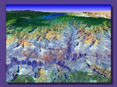
Grand Canyon

. . . roll-over image links for previews or follow the theme trails by clicking on each image to proceed to the next . . .


. . . side-scanning from space . . . and some down-to-earth images of the Grand Canyon.
Also from ASTER are 3D views of Death Valley and Monument Valley.

Labels: ,

. . . since 11/15/06